Asset Tracking for Infrastructure Networks
Asset Tracking for Infrastructure Networks
Managing extensive road networks, bridges, and public infrastructure demands robust asset tracking systems that provide real-time visibility into infrastructure location, condition, and maintenance history. Effective asset tracking transforms how Australian councils, government agencies, and infrastructure operators monitor their transportation assets throughout entire lifecycles. At Asset Vision, we help organisations implement comprehensive asset tracking solutions that enhance operational efficiency and support data-driven decision-making. Contact us to discover how our platforms can improve your infrastructure oversight capabilities.
This article explores asset tracking fundamentals for transportation infrastructure, examining key technologies, implementation strategies, and how modern solutions align with Australian infrastructure management frameworks. You’ll learn practical approaches to tracking road assets, monitoring conditions, and optimising maintenance activities across your network.
Asset Tracking Foundations for Transportation Infrastructure
Asset tracking encompasses the systematic recording and monitoring of infrastructure location, characteristics, condition, and maintenance activities throughout operational life. For organisations managing road networks, this involves documenting every pavement section, bridge, culvert, drainage asset, and ancillary structure within their jurisdiction. Rather than simply knowing these assets exist, effective tracking provides detailed information enabling informed management decisions.
The National Asset Management Framework emphasises comprehensive asset registers as foundational elements for infrastructure stewardship. Infrastructure Australia guidelines recognise that organisations cannot manage what they cannot measure, making accurate tracking essential for demonstrating accountability and optimising resource allocation. State-based authorities including VicRoads and Transport for NSW have established standards for infrastructure asset tracking that reflect best practice approaches.
Modern asset tracking extends beyond static inventories to include dynamic condition monitoring and maintenance history documentation. Each inspection, repair, or renewal activity generates data that becomes part of the asset’s permanent record. This historical information enables trend analysis, deterioration modelling, and predictive maintenance planning that maximises infrastructure value while minimising lifecycle costs.
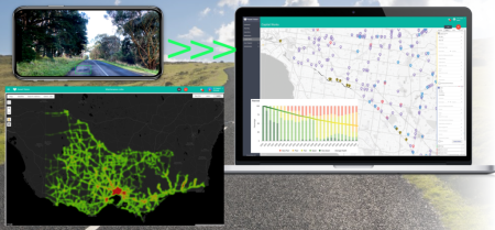
Geographic Information Systems provide spatial context for asset tracking activities, enabling map-based visualisation and location-aware analysis. Understanding where assets exist geographically supports territory-based work planning, emergency response coordination, and identification of geographic patterns in infrastructure conditions. Australian organisations increasingly rely on integrated spatial tracking systems that connect asset data with mapping platforms for comprehensive oversight.
Core Components of Infrastructure Asset Tracking Systems
Successful asset tracking systems comprise several interconnected elements working together to provide comprehensive infrastructure visibility. Unique asset identification forms the foundation, with each infrastructure component assigned a distinct identifier enabling consistent reference across all systems and activities. Hierarchical numbering schemes reflect asset relationships, such as road segments belonging to specific routes or drainage structures serving particular catchments.
Attribute databases capture detailed characteristics about each tracked asset, including construction materials, dimensions, installation dates, design standards, and functional specifications. This descriptive information supports analysis activities requiring asset grouping by common characteristics, such as evaluating all concrete bridges constructed during specific periods or identifying road segments with particular pavement types requiring specialised maintenance approaches.
Location data provides geographic context through coordinates, addresses, or references to larger network structures. Global Positioning System integration enables precise location capture during field activities, while integration with road centreline databases supports linear referencing methods commonly used for transportation infrastructure. Australian Transport Assessment and Planning Guidelines recommend standardised location referencing approaches ensuring consistency across jurisdictions.
Condition records document infrastructure state at specific points in time, creating historical timelines showing deterioration progression or improvement following maintenance interventions. Standardised assessment methodologies ensure comparable data collection across different inspectors, time periods, and geographic areas. Visual documentation through photographs supplements written condition descriptions, providing evidence supporting assessments and enabling remote review by specialists or decision-makers.
Maintenance history tracking connects all activities affecting each asset, from routine inspections through major rehabilitation projects. Understanding what interventions occurred, when they
Asset Vision Co Limited (ASX:ASV)
Head Office:
Melbourne Suite 4,
799 Springvale Rd,
Mulgrave, Victoria,
3170, Australia.
Gold Coast Office:
Ground Floor,
120 Siganto Drive,
Helensvale, 4212,
Australia.
CONTACT DETAILS
Phone: 1800 AV DESK – (1800 283 375)
Gold Coast Office – (0733 870 181)
Email: contact@assetvision.com.au
Terms and Conditions : Privacy Policy : Articles
 –
–