

AI pothole detection is making headlines.
These councils are already putting it to work.
AI pothole detection is attracting fresh attention across Victoria. For councils already using digital road inspections, the experience offers a practical lesson: finding a defect is the beginning of the job.
Recent coverage of Geelong’s AI camera program and the RMIT and RACV Pothole Patrol trial has brought road inspection technology into the spotlight. It is a welcome conversation for communities concerned about damaged roads and councils working to stretch maintenance budgets.
There is already experience to draw on. Moyne Shire was using Asset Vision AutoPilot in 2023. The City of Greater Dandenong’s published 2025 case study describes AutoPilot + AI supporting its road inspections. In New South Wales, Uralla Shire captured its entire road network in one week using AutoPilot in April 2026.
Together, these examples show how road imagery and AI-assisted review can become part of the everyday work of understanding, maintaining and planning a road network.
Years of experience on Victorian roads
At Moyne Shire, the value of a retrievable visual record was clear from the early AutoPilot trials. In coverage published in October 2023, council staff described reviewing road conditions from the office and avoiding return trips to check details across a large rural network.
That history matters. A road image captured today can help answer a question tomorrow, support a maintenance decision months later or establish what a location looked like before a storm. Moyne’s subsequent experience demonstrates the value of visual evidence for disaster recovery claims as well as routine asset management.
In metropolitan Melbourne, Greater Dandenong’s works management rollout brought AutoPilot + AI together with mapped assets, scheduled inspections and updates from field teams. Its case study identifies faster defect identification and resolution among the benefits.
From a potential defect to a maintenance decision
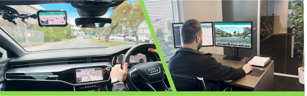
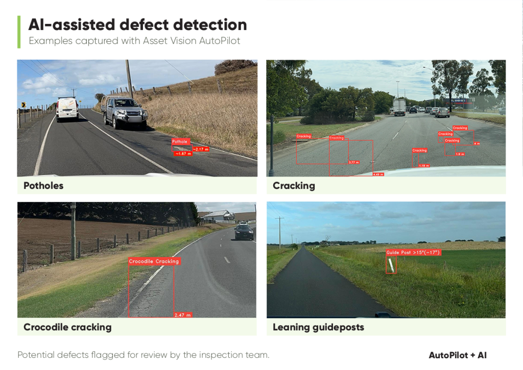
AutoPilot captures road imagery at 10-metre intervals during inspections. AI analyses the images for potential defects, including potholes, cracking, bleeding and flushing, helping teams focus their review on areas that may need attention.
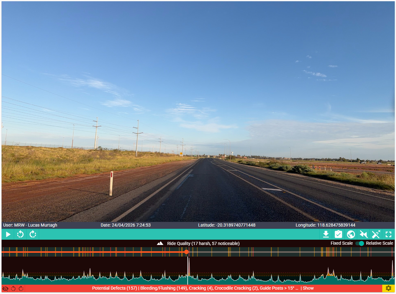
Each image is linked to its location and capture time. Staff can replay an inspection, examine the surrounding road, compare available historical imagery and create follow-up work. Ride quality information adds another perspective on sections that warrant closer assessment.
The council team remains responsible for assessing the evidence and deciding the response. That connection is essential: a flagged defect needs to reach someone who can review it, determine its priority and organise appropriate work.
The value of AI grows when the evidence reaches the people who can act on it.
A whole road network captured in one week
Uralla Shire’s experience gives that approach a tangible scale. Council staff captured the entire road network in one week in April 2026, creating a visual record for subsequent assessment. Council has since also captured its footpath network.
AI-assisted detection helps staff locate potential potholes and cracking within that evidence. The imagery and ride quality insights support closer assessment and more informed maintenance and planning decisions.
AutoPilot is also being used at the City of Kalgoorlie-Boulder, extending its application across metropolitan and regional council environments.
Making every inspection count
AI cannot replace road crews, engineering judgement or maintenance funding. It can help teams spend less time assembling information and more time deciding where their effort is needed.
As more councils adopt AI pothole detection, the opportunity is to connect that capability with the work that follows: reviewing evidence, prioritising defects, organising maintenance and building a clearer picture of how roads change over time.
That is where years of practical experience become valuable. Every inspection can contribute to the next decision, from the field to the office to action.
See how AutoPilot can support your road inspection program.
Explore AI-assisted defect detection, mapped playback and road condition evidence.
Frequently asked questions
How does AI pothole detection work?
AutoPilot captures road imagery at 10-metre intervals during an inspection. AI analyses the images for potential defects, including potholes, and flags locations for staff to review alongside mapped imagery and capture details.
What types of road defects can AutoPilot identify?
AutoPilot supports AI-assisted identification of potential potholes, cracking, crocodile cracking, edge defects, bleeding and flushing, and leaning guideposts. Detections help inspection teams focus their assessment on areas that may need attention.
Does AI replace council inspectors?
No. AI helps surface potential defects within the captured imagery. Council staff review the evidence, assess the issue and determine its priority and appropriate response. Engineering judgement and maintenance decisions remain with the responsible team.
What happens after a potential defect is detected?
Staff can review the location in inspection playback, examine surrounding imagery, compare available historical records and create follow-up work. This connects the inspection evidence with maintenance assessment and planning.
Can AutoPilot work alongside an existing asset management system?
Yes. AutoPilot can operate within Asset Vision or alongside an existing asset management environment. The appropriate integration and workflow depend on the council’s systems and requirements.